

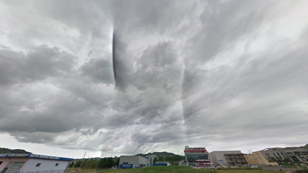
A dirt road stretches far ahead, surrounded by endless hills and diverse vegetation. You can see an old sign hidden by shadows, its letters almost blurred out, but you can still recognize they’re Cyrillic. Where are you – Bulgaria? Kazakhstan? Maybe rural Russia? Welcome to GeoGuessr, a geography game which has recently blown up in popularity on social media. The game drops you somewhere in the world in a Google Street View panorama, and your mission is to use your surroundings to guess your location on the world map. In other words, it’s a world-wide game of hide-and-seek, challenging you to pinpoint where you are using nothing but your eyes and deductive reasoning. GeoGuessr pros use every available piece of information, even some things you would never think of, to reduce their uncertainty and pinpoint their location.
Start Broad, Think Narrow
Rounds in GeoGuessr initially present players with an intimidatingly difficult choice – literally the entire world. The key strategy is simple: shrink the number of plausible locations through logical deduction based on visual clues. Each observation eliminates a massive portion of the world map, like a game of detective.
Driving Patterns and Road Markings
Noticing which side of the road cars are driving on is an extremely easy first cut. Left-side driving restricts options to a handful of countries, like the UK, Australia, or Japan. Additionally, the type and style of road markings can give more context. Long dashed center lines with wide spacing can indicate South Africa, while short, tightly spaced dashes are common in Nordic countries. Double yellow center lines are common across a lot of the Americas, while white center markings are all throughout Europe and parts of Asia. Even the shoulder markings – if they’re solid vs dashed, and which side they’re on – can narrow your guess.
Language and Signage
Language is a huge filter, but look even closer at the fonts and signage layout too. Green highway signs with white sans-serif text are common in North America, whereas European signs can often utilize blue backgrounds. The style of directional arrows, border thickness, and the kerning (spacing between individual characters) can offer guidance. Street name signs mounted on walls vs poles may differentiate urban France from Germany. Certain languages also appear in specific regional combinations. Seeing French and Arabic together, for instance, may suggest North Africa rather than Europe.
Natural Environment
The terrain, vegetation, and soil can give more information than most think. Red or rust-colored soil could indicate Australia or parts of southern Africa. You could see eucalyptus trees not just in Australia, but also in Chile or Portugal. Birch forests with undergrowth are seen throughout eastern Europe. The presence of certain bushes, dry grasses, or banana plants can narrow down the climate zone more precisely than just looking at tree types. Even things like cloud cover patterns and sky tint – whether it’s hazy or crisp – can tell you where you are in terms of altitude and humidity.
Architecture and Infrastructure
Roof materials and shapes are great regional indicators. Clay-tile roofs are seen all over southern Europe, while metal roofs can be seen across parts of Africa and Southeast Asia. Utility poles are another good indicator. For example, concrete poles with triangle shaped holes are prevalent throughout Poland, and V-shaped braces are common in Thailand. Guardrails vary a lot by region – Scandinavian ones usually have a clean silver design, while Balkan countries use heavier rusted models. Don’t forget the sidewalks and curbs, since color striping patterns are often mandated by a region’s local regulations. Power lines can also instantly give away some countries, as some places bury lines entirely, while others suspend them with unique insulator shapes or pole configurations.
Meta Clues
While these are not typically the primary source of deduction, meta clues can help narrow down a guess in cases where typical signs are ambiguous. Different generations of Google Street View cameras have distinct characteristics. For example, low camera height is common in Japan and Switzerland, while high, blurry footage might indicate early coverage in parts of Eastern Europe. Even the Google car itself can be visible in some countries – Kenya and Mongolia have a “black snorkel”, while Ghana’s car often has a duct-taped roof rack. In some rare cases, even the sky can give it away, as there is a known “rift” in the skybox that appears in Albania and sometimes Tunisia, which was just a quirk of early imaging on Google’s part that has since stayed in their Street View. These anomalies, while not always reliable, can offer just enough of an indication for you to push a confident guess into one with full certainty.
Combining Clues Effectively
The real thing that sets GeoGuessr pros apart from average players is their ability to both recognize and integrate multiple clues simultaneously. For example, spotting English language signs alongside left-hand traffic and a lot of greenery would quickly point you to New Zealand or Ireland rather than Canada or the United States. Similarly, seeing Japanese style utility poles and cabbage farms, but Cyrillic instead of Japanese lettering, can steer you toward the far eastern reaches of Russia, near the border with Japan.
GeoGuessr isn’t just about “guessing”; despite what the name may say, it’s fundamentally about reducing uncertainty through analysis, much like a trader at Susquehanna trying to figure out why someone just made a big, unexpected trade. Are they reacting to news? Positioning for a future move? Hedging something unseen? A trader can piece together every clue – timing, price, trade size – to understand what might be driving that decision. In the same way, a GeoGuessr player uses road lines, signs, and terrain to narrow down the map, closing in their possible guess with each new detail.
GeoGuessr teaches players to think strategically when starting from a place of uncertainty, continually reassessing their hypothesis as they gain new evidence. The skill of careful observation, paired with logical deduction, is extremely valuable, even beyond gaming. It directly mirrors the daily decision-making processes that traders and analysts rely on. Next time you play a round of GeoGuessr, think like a trader – notice every detail, use logical deduction, and strategically narrow your path to success.

Subscribe Now
Get each new post sent straight to your inbox